Submitted by Pam Elder on
About those rivers (Genesis 2:10-14)
I originally wrote this article for the Northwest Science Museum, and I’m updating it here for the CSHOF because we are all in this battle together. And you may be wondering what sort of museum is that & what do you mean by “The Northwest”? because if you live in New Jersey, or Indiana, or even California, or New Mexico, or Australia… you may have no idea as to what I am talking about, so let me explain: The Northwest is a group of 4 states, 3 of which are also on the Canadian border. They are the State of Washington (where Mt Saint Helens blew up) and Oregon, both also border the Western Pacific Ocean, and then inland from them is Idaho, and on the other side of Idaho is Montana, where I live. We have some great geological places in Montana! Both Yellowstone & Glacier National Parks are here, and…. the ancient lake bed, which are the remains of “Lake Missoula” that formed the Columbia Gorge, which is the “Northwest Grand Canyon.” The Columbia Gorge goes all the way to the Pacific Ocean and is the border between Oregon and Washington. The Northwest has many other interesting geological features besides these. So what is the Northwest Science Museum? Well… right now we have the contents for the Museum but no building and we are trying to find a spot near Boise, Idaho to set up a permanent location. If the LORD allows us to “set up shop” we will then expound on the marvelous geological features all around us, and how they relate to Creation Science and our amazing Creator. (You can look up the Northwest Science Museum at www.northwestsciencemuseum.com but the original article for this is on my own website under ‘Brain Pickers’ at www.w-rocs.org)
The reason why we have so many interesting geological features in the Northwest is because when the land slid away from the Mid Ocean Ridge in the Atlantic during the Flood of Noah, when it slid over here, it went right over the top of the Mid Ocean Ridge in the Pacific Ocean, and there it became stuck! As a result, the land buckled up into mountains and valleys, and what was underneath melted into magma, which later leaked out all over the Northwest, and… we still have some hot spots below us! On one side is the Yellowstone and on the other side are the chain of volcanoes along the Pacific Coast, including Mt Saint Helens.
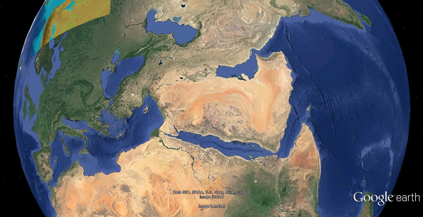
Now hang on to your seats, ‘cause we’re going to switch gears here. In a similar way, on the other side of the world you will find that the Mid Ocean Ridge runs across the Indian Ocean and then up through the Gulf of Aden along the Red Sea and eventually up through the Boot of Italy.
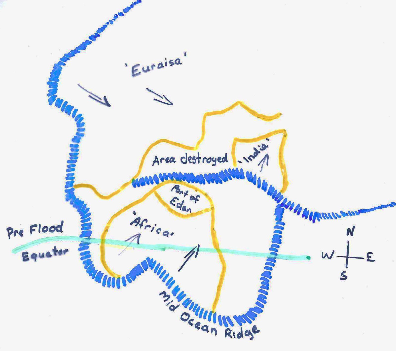
 When Africa slid away from the Atlantic section of the Mid Ocean Ridge, like the area in which I live, it went right over the top of another part of the Mid Ocean Ridge. It then did a head on collision with Eurasia which was sliding away from the Mid Ocean Ridge in the Arctic, and in the process the Caucasus Mountains, etc. were formed. During the momentum, the rest of Africa kept sliding for a time, causing the Saudi Arabian Peninsula to break off somewhat at its weakest point, which was right over the “Aden/Eden” section of the Mid Ocean Ridge. The following “rough” illustration is at the beginning of the slide. Where it says “area destroyed,” that’s the section of the land of Eden that vanished when the Fountains of The Great Deep broke open. Anything for about 400 miles on either side of the Mid-Ocean Ridge was eroded away by the Fountains of the Great Deep during the first 40 days & nights of the Flood. [& even though it’s shaped like Africa, in reality, it’s edge would have been the shape of the edge of the Mid Ocean Ridge it was about to cross over. ]
 Notice how “Israel and Lebanon” were right on the edge of the Mid Ocean Ridge. If you go about a dozen or so miles off the coast of Lebanon, you will find that the ocean is over a mile deep. Apparently the river that entered the Garden was washed away during the Flood, and the Garden itself is buried underneath Lebanon and possibly Northern Israel. How do I know this? Well, In Ezekiel 31 it says that the Trees of the Garden are buried beneath Lebanon (verses 3, 9, and 16, with verse 16 being the key.) God’s Garden (Lebanon) was completely inundated with the mud that came out of The Fountains of The Great Deep! Ezekiel 28 also mentions God’s garden, and says that the land of Tyre was cast off of the ‘Mountain of God’ in God’s Garden (See verses 13 and 16. It’s not just about the devil, but it’s also about the landscape!) It’s probably describing how a portion of the mountain that existed in the Garden was eroded away by the Flood waters and then dumped in the location of the Biblical Tyre.
Post-Flood description of pre-Flood location
Why am I telling you all this? It’s because Genesis 2 is a Post Flood description of a Pre Flood location, probably given before the Days of Peleg. How do I know this? The location of the rivers coming out of the Garden of Eden are described, but there is no location given of the river that entered Eden. In order to understand where the locations of the rivers are, you have to first understand what happened during the Flood, and right afterwards.
The ‘Land of Eden’ contained God’s Garden, just like a country contains it’s national parks, & just like national parks are only a small part of a given country, so also the Garden of Eden was only a part of the Land of Eden. Apparently the “Land of Eden” encompassed the entire Middle East, because the “Gulf of Aden” can be translated as the “Gulf of Eden.” “Aden” is how “Eden” is said in Hebrew. Another clue is that one of the earliest names (9th generation Irish) in the Royal European Genealogies presented in After the Flood by Bill Cooper is Hebrew and it means “Eden is hidden from my eyes”( See http://www.w-rocs.org/stones/Magog_and_Javan_Descendants.pdf) and the names following that one are no longer Hebrew words. Magog (who was also the ancestor of the Irish) for a long time inhabited the area between the two lakes on the border of Turkey and Iran below Mt Ararat, so my guess is that the land of Eden at that time extended to the border of the Caucasus mountain range.
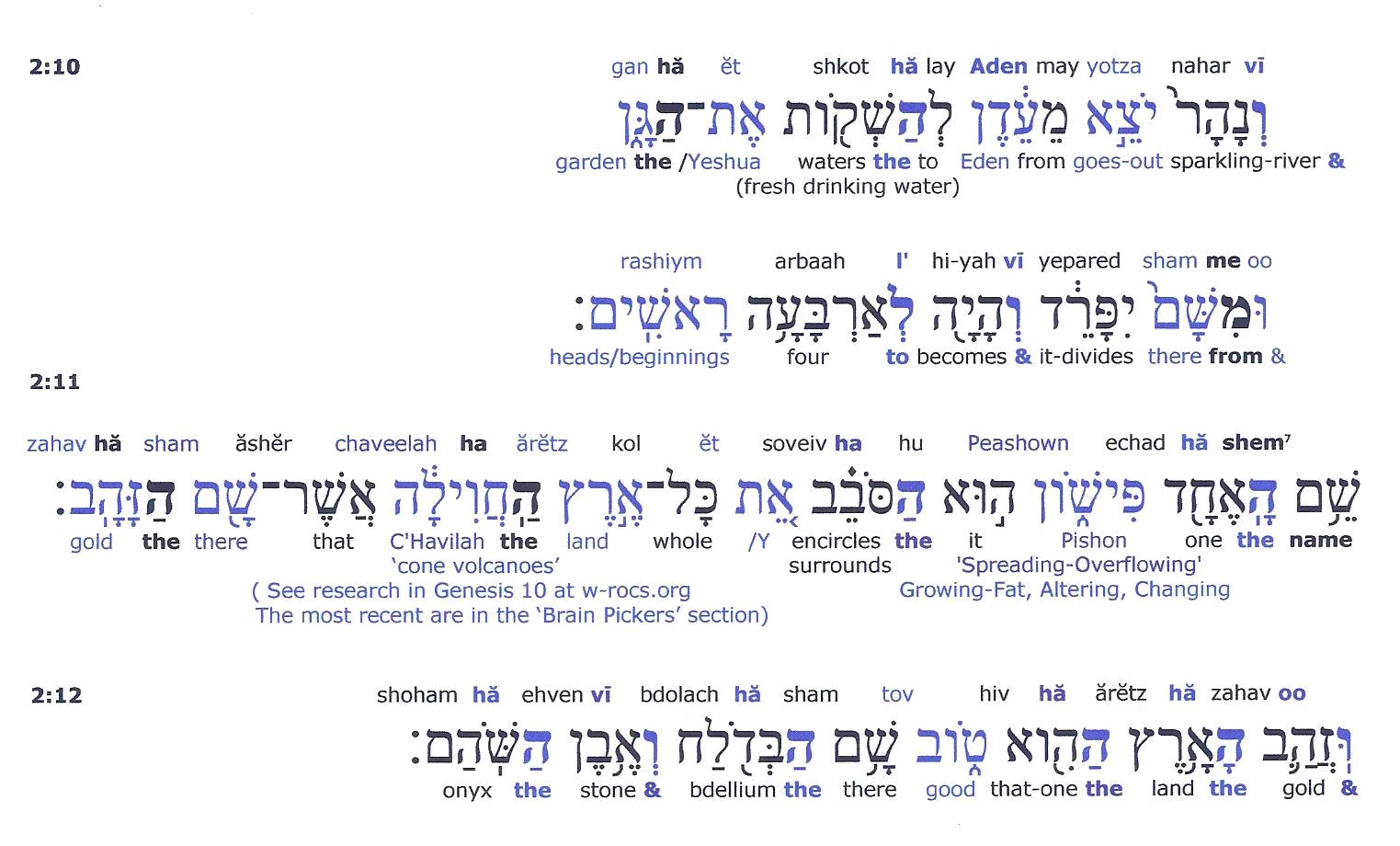
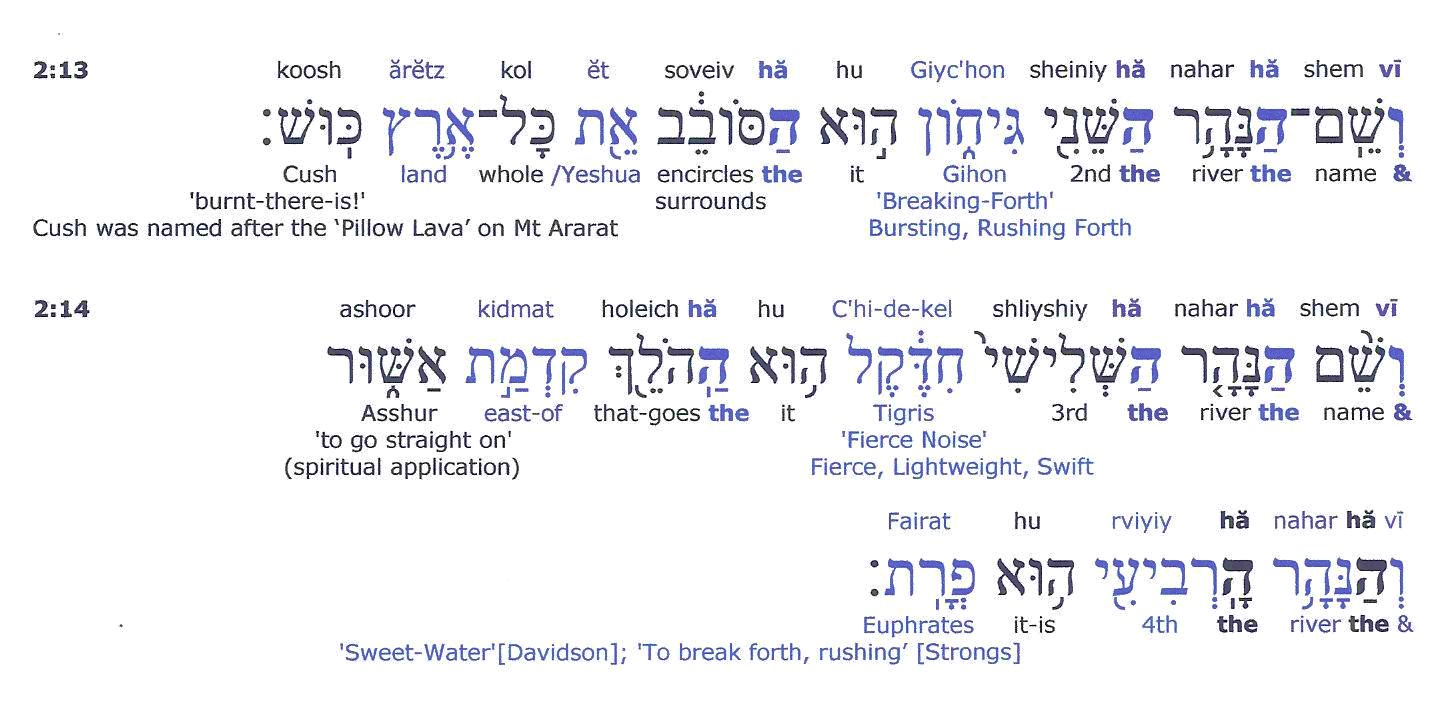
Another clue that Genesis 2 is a Post Flood description of a Pre Flood location is that the names of the lands are Post-Flood people, two of whom were named after Post-Flood volcanic activity. Cush was named after the pillow lava on Mt Ararat. Cush means “burnt there is!” and Havilah, which means “circular” was first given as a name describing the formation of Lesser Ararat, which is a cone shaped volcano. Those particular names, given in relation to volcanic activity, didn’t exist before the Flood, because there was no volcanic activity before the Flood. (See http://www.w-rocs.org/Brain%20Pickers/Brain_Pickers_Genesis_10_part_1.pdf )
Are you still hanging on to your seat? Hang on tight, because I have to add one more thing into the mix. At the time that this description was given, the earth was still rolling as a result of the mountains being formed during the Flood, because the Tigris is still “east” of Asshur. Nowadays it’s ‘south’ of Asshur. [See #71 at http://www.creationscience.com/onlinebook/HydroplateOverview9.html and also see “Earth Roll” starting on pg1 at http://www.w-rocs.org/Brain%20Pickers/Brain_Pickers_Genesis_10_part_2.pdf ]
Also keep in mind that in the centuries right after the Flood, when the description was given, there would have been more water in the Middle East. At that time, because of the earth roll, the jet streams would have been coming from a different direction over the Middle East. During the days of Shem, the ‘Empty Quarter’ (in Saudi Arabia) was still a lake. If you study out the ancient drainage systems in the land of “Havilah” (which includes Medina, and inland from there in Saudi Arabia) you will find that they skirt the area and then drain towards the Persian Gulf. That could be the general location of the “Pishon” river right after the Flood. Shem lived to be 600 years old, and therefore he and his two brothers would have lived long enough to have explored the whole area and compared it with maps of the Pre-Flood world, and recorded their Post-Flood location, even though the original rivers were buried in the earth below. And as you study this area you will also notice that the Saudi Arabia side of the Great African Rift Valley is lined with a string of volcanoes (& in some places clusters of them) all the way from Yemen to Ararat, & every one of these is Post Flood. (See Google Earth. www.earth.google.com ) As they developed in the centuries after the Flood, they may have altered the drainage system of the Pishon.
Another thing to consider, is that right after the Flood, the water levels in the oceans were much lower than they are today, by several miles. [See “Recovery Phase” at http://www.creationscience.com/onlinebook/HydroplateOverview7.html#wp14343576 ] Because of this, most likely, the Red Sea probably didn’t exist at that time. There may have been some long narrow lakes in the deepest parts of it, or maybe not, depending on whether volcanic activity choked the drainfield further down towards the “elbow” of the Gulf of Aden. That area is probably the location of the Gihon River. If you examine a “Table of Nations” Bible Map, Cush’s descendants are settled on both sides of the Southern part of the Red Sea. The settling must have occurred before the ocean water levels rose up. With all this said, now let’s look at the Genesis 2 Hebrew Text
Was there gold before the Flood?
We have a gold nugget that was found in the middle of Australia, just lying in the dirt, somewhere in the Outback. It was probably washed out during the Flood. It’s porous. You can tell that it’s never been under intense heat. It wasn’t found where mountains were pushed up at the end of the Flood⁸. There are also written accounts of gold chains being found encased in clumps of coal⁹. In Saudi Arabia, in ancient times, gold was mined in the area around Medina (It’s on the Red Sea side near Mecca.) If you look it up on Google Earth, you will also find lots of ancient volcanic activity inland from there.
As everybody knows, the Tigris and the Euphrates are “alive and well.” The headwaters of both rivers are in Turkey. Then the Euphrates travels through Syria and Iraq while the Tigris enters Northern Iraq, continues down through Baghdad, meets up with the Euphrates just above Kuwait and then exits the Persian Gulf on the border between Iran and a little tiny strip of land that belongs to Iraq (& on the other side of this tiny little strip of land is Kuwait). Did you know that Baghdad is about 60 miles north of the ancient city of Babylon /Babel ? The Euphrates flows right past Babylon on its way to the Persian Gulf. [And there’s more to come in that department as it’s mentioned quite a bit in the Book of Revelation! Currently Babylon is going through the process of being classified as a ‘World Heritage site’. To see it type in ‘Ancient Babylon, Iraq’ on Google Earth. The complex is about 11 miles northeast from the Euphrates river, and a couple miles north of the city of Hillah.]
A list of my resources, references, etc. for these ‘Dissecting Genesis 2’ articles can be found on the last pages of http://www.w-rocs.org/Brain%20Pickers/Brain%20Pickers%20Genesis%202!.pdf


4 Comments
Submitted by TheDiggPatriots (not verified) on
Genesis 1 repeats often the construct "aleph-tav," pronounced "et." COuld it really means "Alpha and Omega," that... http://t.co/6J9tCo1gqs
Submitted by Politicollision (not verified) on
Genesis 1 repeats often the construct "aleph-tav," pronounced "et." COuld it really means "Alpha and Omega," that... http://t.co/uROrDrKqk2
Submitted by AmericanPraise (not verified) on
RT @Creationtips: Jesus in Genesis Chapter 1? (Hall of Fame) | http://t.co/qF8h4EGX0C
Submitted by Creationtips (not verified) on
Jesus in Genesis Chapter 1? (Hall of Fame) | http://t.co/qF8h4EGX0C